

Preserve burial mounds from the comfort of your own home
The new Erfgoed Gezocht/Heritage Quest website means you can play armchair detective and hunt for undiscovered burial mounds in the Veluwe. This will help stop them being destroyed by construction projects. The website is the initiative of the Leiden University Faculty of Archaeology in collaboration with the Gelderland Heritage Foundation.
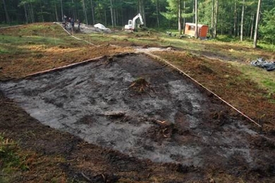
We know they exist, but their exact location is still a mystery: burial mounds that were constructed between 3,000 and 500 BC. Often one body was buried under such a mound, with others being added sometimes as many as 1,000 years later. ‘Burial mounds have the same cultural and historical value as megalithic tombs,’ says Leiden archaeologist Quentin Bourgeois. ‘But they are less visible and therefore relatively unknown. A burial mound is one metre high on average.’ As these mounds are easy to miss and their location is unknown, this puts them at risk of being accidentally destroyed, for instance during construction work.
Twice as many
A special website has been launched to help prevent these burial mounds from being destroyed and to increase public awareness of them: www.erfgoedgezocht.nl. Here you can volunteer to hunt – in the comfort of your own home – for burial mounds in the Veluwe. The site has not been chosen at random, says Bourgeois. ‘It is a very wooded area, which makes it difficult to locate burial mounds. At present, we know the location of about 1,500 burial mounds in the area. We hope to double this soon.’
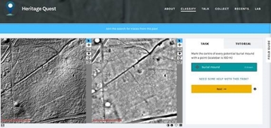
Volunteers will also be able to look for Celtic Fields (2,500-year-old field systems) and pits used to burn wood to produce the charcoal that was used to smelt iron, for instance. This game of hunt the burial mound is possible thanks to LiDAR maps of the area. These are maps that show height differences in the Dutch landscape. Every 50 square centimetres of the Netherlands has been measured, resulting in a very detailed map of the country’s surface. An army of armchair volunteers is now needed to pinpoint the location of burial mounds, Celtic Fields and charcoal pits on these maps.
Detailed maps
On the website volunteers first learn how to identify burial mounds before they can start playing armchair detective. Experts will look at all their findings and produce detailed maps, which they will make available to provinces, municipalities and anyone else who might benefit from this information. The will therefore help preserve the burial mounds.
AI systems also scouring the maps
It is not just people who will be scanning the LiDAR maps for burial mounds: artificial intelligence (AI) systems will be doing the same in the project of Leiden archaeologist Wouter Verschoof-van der Vaart. Their findings will be compared with the ‘human’ findings. The researchers thus hope not only to discover more burial mounds but also to to teach the AI systems to become increasingly accurate.
It is not yet known when the burial mounds in the Veluwe will have been found. If the project is a success, Bourgeois will also give other provinces and municipalities the opportunity to enlist the help of Erfgoed Gezocht/Heritage Quest to find ‘their’ burial mounds.