
Research project
Mapping Historical Leiden: A Dynamic and Digital Atlas (Phase 1 & 2)
The map application includes information from old and new buildings archaeological projects. This makes it possible to investigate whether water facilities (wells, cisterns) and waste facilities (cesspits, sewers) were the privilege of Leiden’s wealthy elite in the late 16th and 17th centuries or whether all inhabitants had access to them.
- Duration
- 2015 - 2016
- Contact
- Roos van Oosten
- Funding
-
 NWO-Alfa Meerwaarde
-
 DANS Kleine Data Projecten
- Partners
Leiden University
University of Amsterdam/University of Groningen
Heritage Leiden and Region
Fryske Akademy
Short Abstract
The online map application Mapping Historical Leiden facilitates an integrated analysis of historical, archaeological and buildings archaeological data from Early Modern Leiden, as well as offering accessible presentation of these data to a broader public through Heritage Leiden and Region’s website.
Project Description
A town in a turbulent transition
Prior to the Siege of Leiden (1573–1574), the town was a medium-sized textile centre with about 12,000 inhabitants. This was still the case at the time of the 1581 census. Shortly after, Leiden welcomed hundreds upon hundreds of refugees fleeing the war engulfing the southern Netherlands, and in less than two decades, the population of Leiden doubled. The explosive demand for housing must have had an enormous effect on the town’s community as the town walls were not expanded.
Many detailed historical, cartographic and archaeological sources are known from this period, and Mapping Historical Leiden uses cutting-edge computer applications to link different datasets based on these sources. Analysis will generate a detailed understanding of the rapidly shifting nature of the buildings environment, particularly the spatial inequality and disparities over time (1557–1606).
Social relevance
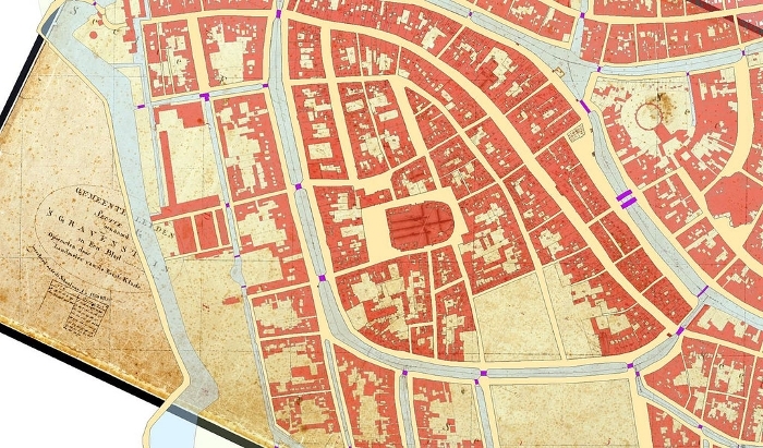
A cadastral map avant la lettre (c. 1585) of Leiden
Real estate and property have been registered and mapped systematically in Leiden since c. 1825. As early as 1585, Leiden town councillor Jan van Hout put together a ‘cadastral’ map of the town of Leiden. This series of maps is known as the Straten- en Grachtenboek (Book of Streets and Canals; De Baar 1985).
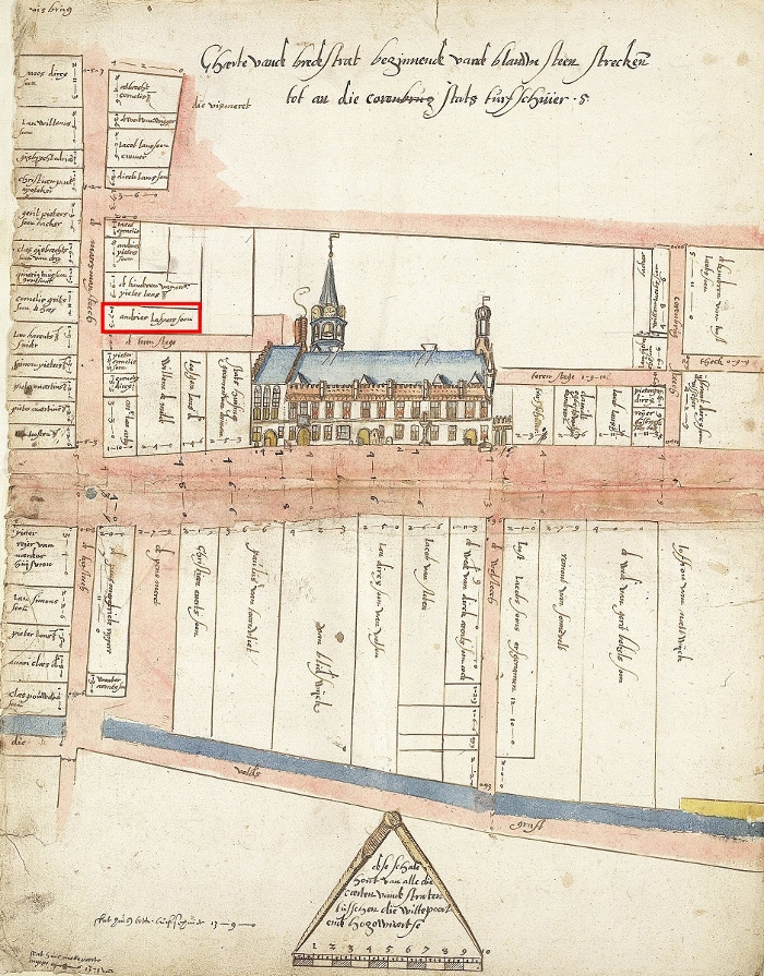
(Stadsarchief van Leiden, 1253–1574 (SAII), inv.nr. 5153, “Straetbouc”, kaart 04, scan 12.
https://www.erfgoedleiden.nl/collecties/archieven/archievenoverzicht/inventaris/memorixscans/zoekterm/stratenboek/aantal/20/eadid/0501A/scans-pagina/4/inventarisnr/5153/pagina/1/scan-index/12/fotouuid/f55ca7be-f4c1-4f56-9813-f3b59b0577dc)
The Straten- en Grachtenboek lists the owner’s name and the frontage of every plot. For example, Maarsmansteeg 12 was owned by Gerrit Ysbrantsz, baker by trade, and its width is given as 1-7-5 (1 Rijnlandse roede/rod [3.767358 m], 7 voet/feet [0.3140 m] and 5 duim/thumbs [0.0628 m], that is, 6.3 m).
Who lived where?
This cadastral map avant la lettre is vital in linking tax records and the property registry of aspecific location (Van der Vlist 2001). For example, we know that the baker Ysbrantsz of Maarsmansteeg 12 had seven hearths as recorded in the Tax Register on Chimneys for 1606.
Thirteen of the historical registers have been transcribed and are digitally accessible in the Dröge database. At present, however, querying the database is not only time consuming, but also requires a certain expertise in databases. Mapping Historical Leiden (Phase 1) will ensure that every visitor to Heritage Leiden and Region’s website will be able to access the entire history of houses in the bon Wanthuis with one mouse click.
Scientific relevance
In his 1975 monumental atlas, architect Van Oerle demonstrated that by combining data from tax records and the Straten- en Grachtenboek, a high-resolution image of the town could be generated. Since 1975 much more historical research has been carried out.
The historical GIS-application Mapping Historical Leiden links several types of data: cartographic, historical buildings, archaeological and historical data. This linkage allows complex queries at several levels (micro, meso and macro): the town as a whole, individual neighbourhoods, building blocks or plots.
Why a consortium?
(Source map: H.A. van Oerle, 1975: Leiden binnen en buiten de stadsvesten , Brill, volume 2, Map 7a.)
To realize the map application, a consortium has been formed consisting of Leiden University, University of Amsterdam and Heritage Leiden and Region.
Leiden University
Van Oosten (Leiden University), project manager, is an historian and archaeologist and the author of De stad, het vuil en de beerput, an historical-archaeological book on sanitation infrastructure in urban Dutch society (in press). She lectures on urban archaeology and is familiar with Heritage Leiden and Region.
She was team leader of the project DANS Small-Data Project (DANS Kleine Data Project) Mapping Pre-industrial Sanitation Infrastructure in the Town of Haarlem for which a map application with similar features was developed.
University of Amsterdam
Van Steensel (University of Amsterdam) is a social economic historian of the late Medieval and Early Modern period, who focuses on the institutional and social economic history of Leiden. Historical GIS-applications have a major role in his research. In addition, he is a member of Amsterdam’s Centre for Urban History and Centre for Cultural Heritage and Identity, a platform for staff and students who participate in research projects that have been set up by heritage institutions and private partners.
Erfgoed Leiden en Omstreken/Heritage Leiden and Region
Established in May 2013, Heritage Leiden and Region manages the regional historical archives and carries out and coordinates archaeological and buildings archaeological projects in Leiden. This municipal service currently has a staff of 50, and approximately 90 volunteers assist in its operations on a weekly basis.
Heritage Leiden and Region is not only the regional knowledge hub of the history of Leiden, but is at the cutting edge of digitisation. Its website was awarded first prize in the category ‘government’ for its open-access approach. In the heritage sector, Heritage Leiden and Region is a trailblazer in public outreach through sophisticated websites, virtual maps and apps. The academic need for a research tool such as Mapping Historical Leiden aligns perfectly with the mission of and expertise offered by Heritage Leiden and Region.
Experts and critical test panel/advisory board
The consortium of institutions is actively supported by the work of Jan Dröge, MA (Dröge, Bureau voor de Bouwhistorie), a buildings historian and expert on Leiden’s history. He has volunteered countless hours transcribing historical registers and has created the datasets that will be used in the project.
In addition, a test panel/advisory board has been established consisting of Emiel van der Hoeven, MA (volunteer at Heritage Leiden and Region) and two academic researchers, PhD candidate Marcel IJsselstijn (Leiden University) and Prof. Bram Vannieuwenhuyze (University of Amsterdam).
Results & Conclusions
Take a look at our results.
Phase 2:
Historical geocoder
The DANS grant will make possible the development of a full-fledged research tool using digital infrastructure. Linking historical tax records to specific locations is arduous, since house numbers were not used prior to the 19th century. We are fortunate that the Straat- en Grachtenboek (Book of Streets and Canals), a late 16th-century cadastral map avant la lettre, exists for the town of Leiden.
Complicating the matter, however, is the fact that town lots have been divided and amalgamated repeatedly since the 16th century. Specialized historical knowledge is needed to sort through the data, and the team is pleased to have available the expertise of independent researcher Jan Dröge. A historical geocoder will be used to ensure that geographical units and historical data will be linked correctly. The applied historical geocoder tool was developed as part of the Erfgoed & Locatie project (Heritage and Location).
Leiden’s cadastral maps of 1832
In addition, the DANS grant will contribute to the digitisation of the cadastral map of Leiden (1832), as part of the longstanding HISGIS project of the Fryske Akademy in Leeuwarden, coordinated by Prof. Hans Mol. The historical GIS project aims to digitise and vectorise all 1832 cadastral maps of the Netherlands.
Literature
Baar, P.J.M. de, 1985: ‘Jan van Hout en zijn Stratenboek en Grachtenboek’, in: Ups en Downer. Bundel artikelen bij het afscheid van mr. W. Downer als gemeentearchivaris van Leiden, Leiden, 5–18.
Dröge, J., n.d.: ‘Vestmeesterrekeningen. Leiden 1460–1465’, bronpublicatie beschikbaar op www.janvanhout.nl.
Oerle, H.A. van, 1975: Leiden binnen en buiten de stadsvesten. De geschiedenis van de stedebouwkundige ontwikkeling binnen het Leidse rechtsgebied tot aan het einde van de Gouden Eeuw, 2 delen, Leiden.
Oosten, R.M.R. van, in press: De stad, het vuil en de beerput. De opkomst, verbreiding en neergang van de beerput in stedelijke context, Leiden: Sidestone Press.
Vlist, E. van der, 2001: ‘De bonboeken te Leiden’, in: G.A.M. van Synghel (ed.), Bronnen betreffende de registratie van onroerend goed in de Middeleeuwen en Ancien Régime, Den Haag, 83–104.