
Research programme
Landscapes of Survival
Pastoralist Societies, Rock Art and Literacy in Jordan’s Black Desert (200 BC to 800 AD)
 Netherlands Organisation for Scientific Research
Research question
The central goal of the pioneering ‘Landscapes of Survival’ project is to develop a far-reaching understanding of the desert cultural landscape and to explain the prominent achievements of the indigenous pastoralist peoples between 200 BC and 800 AD. What were the fundamental social, political, economic and ideological strategies which allowed the populations of Jordan’s Black Desert to successfully exploit this difficult-to-inhabit region? How did people cope with the marginal environment in which they were living? And how were the local communities embedded in the supra-regional political and trade networks of their time?
Short abstract
‘Landscapes of Survival’ is a research project, sponsored by the Netherlands Foundation for Scientific research, that investigates the archaeology, rock art and epigraphy of nomadic pastoralists in the Jebel Qurma region in Northeast Jordan from Hellenistic to Early Islamic times.
Pastoral nomads of the Black Desert
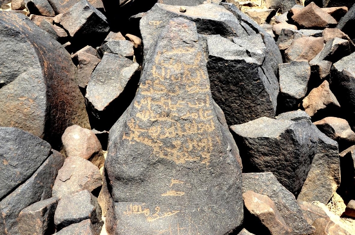
The ‘Black Desert’ in northeastern Jordan is a vast expanse of rough basalt boulder fields and endless gravel plains. Despite the many environmental constraints and severe ecological marginality, the basalt desert appears to be astonishingly rich in all kinds of archaeological remains. High-resolution satellite imagery and new fieldwork in the Jebel Qurma region near the Saudi border revealed hundreds of previously unknown habitation sites and burial mounds and thousands of rock carvings and inscriptions in Safaitic, dating between roughly 200 BC and 800 AD (Hellenistic to early Islamic periods). These were the works of pastoralist groups with a mobile lifeway centred on hunting-and-gathering, sheep-goat herding and camel nomadism.
Until recently the nature of the pastoral societies in the desert was mainly reconstructed on the basis of generalized epigraphic evidence from the desert at large and from external literary sources from the Roman world and beyond. The ‘Landscapes of Survival’ project, however, seeks to obtan a more directly informed understanding of the pastoral communities, by studying archaeological and epigraphic data from a local landscape that was frequented by nomadic communities in the past.
Multidisciplinary research
‘Landscapes of Survival’ is a multidisciplinary research programme which aims to bring the rich, new datasets (settlements, burials, rock-art, inscriptions) in a single interpretive framework, which has not been done before. It focuses on the social, political, economic and ideological strategies which allowed the local peoples to successfully exploit their inherently marginal landscapes from the Hellenistic to early Islamic periods.
The ongoing research into the social structures and fabrics in the Black Desert, and their embedding in the natural and cultural landscapes, elaborates on new insights from archaeology, iconography, epigraphy and the natural sciences. This integrated research effort will put our current, fragmentary knowledge of the cultural significance of the vast desert and its ancient peoples in a completely new light.
Survey and excavation
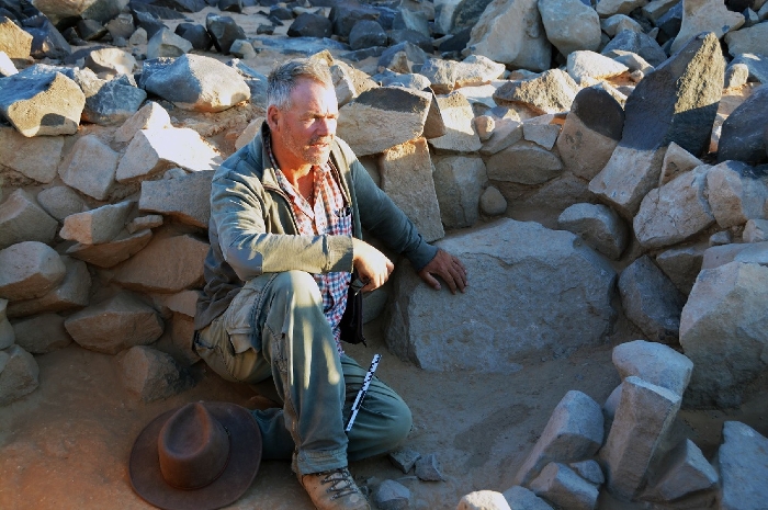
The project elaborates on new fieldwork in the Jebel Qurma region (as part of the Jebel Qurma Archaeological Landscape Project), an area of roughly 300 km² in the midst of Jordan’s Black Desert, about 30 km east of the modern oasis town of Azraq, close to the Saudi border. New archaeological and epigraphic data are being gathered through intensive field surveys in the Jebel Qurma region. Excavations are carried out at selected places in the area: burial tombs, enclosures, camp sites, etc.
Research projects
‘Landscapes of Survival’ is a joint research project of the Faculty of Archaeology (Prof. Peter Akkermans) and the Faculty of Humanities (Dr. Ahmad Al-Jallad) of Leiden University.
In the form of three PhD projects, the ‘Landscapes of Survival’ programme investigates: (1) pastoralist lifeways and the treatment of the dead in the desert, (2) the role of rock-art in signing the landscape, and (3) the implications of widespread literacy among the local peoples in the desert.
Ways of Life and Death in a Pastoralist Landscape
How did people, 2000 years ago, order and structure the marginal landscape in which they were living, in terms of settlement and the treatment of the dead? How were people engaged in the creation of meaningful landscapes?
This PhD project, carried out by Harmen Huigens, examines patterns of mobility and the development of the ways of life and death across the desert landscape between the Hellenistic and early Islamic periods. Previous views on ancient pastoral nomadic communities that inhabited the Black Desert have been based exclusively on historical sources. Alternatively, this research provides an archaeological perspective on these communities, which has not been done before.
The application of satellite remote sensing and aerial photography at different resolutions is crucial to this study. By applying a combined methodology of remote sensing, intensive surface surveys, and targeted excavations, new field research in the Jebel Qurma region has disclosed a wealth of archaeological remains of these pastoral nomads, including their campsites, funerary monuments, ancient routes, artefact scatters, etc. A Geographic Information System (GIS) is created, including field data, satellite imagery, aerial photos, digital elevation models, and topographical, geological, climatic, hydrological, historical and ethnographic information layers.
The research aims at the reconstruction of the dynamic social landscape and its underlying strategies and fabrics. Mobility was vital to the desert communities which were organized along lines of tribal affiliation and pastoral subsistence. Hence, insight into mobility is at the very heart of interpretation and essential to the proposed study. Research will focus on the tangible remnants of regional pastoral praxis and their implications for the recognition of adaptive practices, strategic choices and modifications in the natural and social environments. Crucial is also insight into the regional funerary landscape, with regard to the many burial monuments in the desert and their location, variability in layout and construction, spatial and temporal diversity, recurrent use, relationship to sites and routes, etc.
Figurative Narratives: Rock Art in a Pastoralist Landscape
How did the desert groups order and structure the social and natural landscape, in terms of the many pictorial representations embedded on stone in the landscape between the Hellenistic and early Islamic periods?
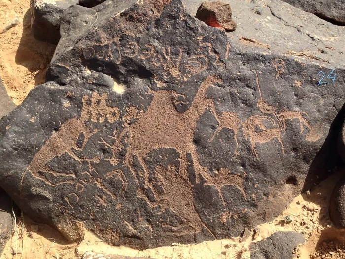
Our current fieldwork in the Jebel Qurma region yielded thousands of petroglyphs, predominantly figurative in nature and with clear visual cues for recognition of depicted subjects: wild and domestic animals, warriors, horsemen, camel caravans, dances, hunting scenes, etc. They contain visual information on important features from daily life not represented in other types of archaeological evidence. Because of their fixity in places, these carvings articulate what were key elements in organizing the desert landscape – or in “signing the land” in the words of Richard Bradley – and inform us how this landscape was perceived and used in the period between 200 BC and 800 AD. With the field of Arabian iconography still in its infancy , the researcher will be tasked with pioneering several important research avenues.
This PhD project, carried out by Nathalie Brusgaard, comprises, first, the categorization of local rock-art, aimed at insight into the rock-art corpus at large and the variability therein, in order to trace cultural identities and territorial boundaries. It focuses on subject-matter, composition, orientation, classification and quantification of designs, organisation of motifs, comparison of different groups with another, production techniques, chronology, and symbolic and stylistic diversity. With regard to its dense and widespread distribution, the imagery from Jebel Qurma must have been both inscribed and understood by many people, as part of shared experiences and identities.
Second, the project investigates the local rock-art and the contexts in which the images were created. It analyses the rock-art and its changing content in relation to topography, to the movement of people in their landscape, and to the occurrence of monuments and features (dwellings, burial cairns, enclosures, stone markers, paths, etc.). The common co-occurrence of burials and rock-art suggests that the dead and ancestors were of salient importance for the ways in which the landscape was being used and interpreted. Both locational analysis and view-shed analysis may provide important clues in investigating the structural relationship between landscape and rock-art.
Third, the rock-art in the Jebel Qurma region often occurs in association with contemporaneous inscriptions in Safaitic, which offers us an extraordinary source of insight passed on directly from those who made and used the images. We can, as it were, “read” and interpret the rock carvings from the inside, rather than relying solely on the images per se or to their place in the land.
Literacy and Identity in a Pastoralist Landscape
How did the peoples of the desert order and structure their social and natural landscape, in terms of the thousands of Safaitic inscriptions which they added to and incorporated in the landscape?
The archaeology of the Black Desert in the period between 200 BC and 800 AD will deepen our understanding of the indigenous communities, their histories and material culture, which, until now, were known almost exclusively from (external) literary sources. However, the many informal Safaitic inscriptions (often in combination with rock-art) in the desert provide another, invaluable avenue of research, with the potential to shed historical light on these ancient pastoralist communities.
The many texts express the identities, daily activities, prayers, hopes, and fears of their inscribers and give us a new vista from which to understand ancient pastoralist societies and lifeways. This PhD project, carried out by Chiara Della Puppa, explores the meaning and implications of Safaitic epigraphy vis-à-vis the cultural, pastoralist landscape to which it was inextricably tied.
The thousands of Safaitic inscriptions represent the material account of pastoralist thought and action in the Jebel Qurma landscape, largely preserved in place since their moment of creation. They inform our understanding of how indigenous peoples experienced, manipulated and referenced (through text) to their desert environment. This study investigates the contexts in which the inscriptions were used, their location in the cultural and natural landscapes, and their relation to dwellings and burials. It aims to identify regional patterns of pastoralist identity and movement, locational preferences, visibility, and markings of roads and social boundaries. It will also yield insight into the relations between the living and the dead, because of the dense distributions of inscriptions in association with burials.
In mapping the many epigraphic, narrative, ritual and social dimensions of the inscriptions, this project will contribute to the theoretical reflection on the role of literacy in non-urban contexts and its use in the construction of individual and collective identities in small-scale societies.
Publications
Akkermans, P.M.M.G., H.O. Huigens, M.L. Bruning (2014): A Landscape of Preservation: Late Prehistoric Settlement and Sequence in the Jebel Qurma Region, North-Eastern Jordan. Levant 46 (2): 186-205.
Akkermans, P.M.M.G. (2014): Jabal Qurma Archaeological Landscape Project. American Journal of Archaeology 118 (4): 628-630.
Akkermans, P.M.M.G., H.O. Huigens(2014): De Archeologie van de Zwarte Woestijn: Jebel Qurma in Noordoost-Jordanië. In: O.E. Kaper en J.G. Dercksen (red.), Waar de geschiedenis begon. Leiden: NINO, pp. 277-286.
Brusgaard, N.Ø. (2015): Pastoralist rock art in the Black Desert of Jordan. XIX International Rock Art Conference IFRAO 2015. Arkeos 37: 761-767.
Huigens, H.O. (2015): Preliminary Report on a Survey in the Hazimah Plains: a Hamad Landscape in North-Eastern Jordan. Palestine Exploration Quarterly 174 (3): 180-194.
Huigens, H.O. (2015): Ways of Life and Death in a Pastoralist Landscape: An Archaeology of Nomadism in Jordan’s Black Desert Between Hellenistic and Early Islamic Times. Tijdschrift voor Mediterrane Archeologie 53: 54.