Website
Bestrijdingsmiddelenatlas (BMA) - Pesticide Atlas of Dutch surface waters
Improving environmental risk assessment of pesticides in surface waters
- Author
- CML - Environmental Biology
- Date
- 03 May 2019
- Links
- Website Pesticide Atlas (Dutch)
Introduction
The Pesticide Atlas, BMA (Dutch: BestrijdingsMiddelenAtlas) is a key research instrument/tool of the Department of Environmental Biology (EB). Throughout the course of the year, all Dutch regional water managers (water boards) and national water managers (Rijkswaterstaat and VEWIN) are required to monitor the quality of their surface waters, and test for, amongst other things, the presence of pesticides and their metabolites.
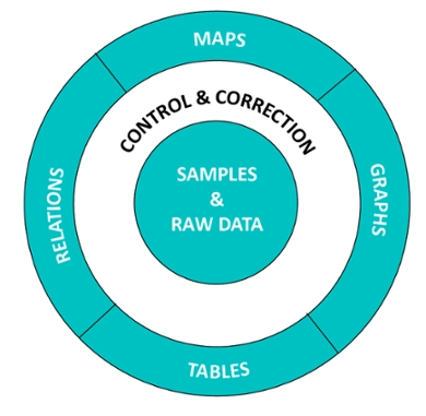
These raw monitoring data are processed every year, if needed corrected, and compared with the regulatory standards for the different substances to create a standardized and comparable dataset.
The Pesticide Atlas then integrates this dataset to provide a national overview (in either map, graph or table form) of the pesticides and their metabolites in the surface water. For example, it can be used to draw a map of where and how often in a certain year in the Netherlands, the neonicotinoid pesticide imidacloprid exceeds the standard exceedances of the EQS-AA.
Since the Pesticide Atlas provides data from 2001 onwards, it can also provide trends of measured concentrations or exceedances over time. The results can also be provided per region, rather than national.
Framework
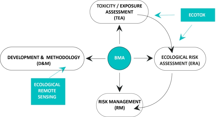
The corrected datasets and derived products of the Pesticide Atlas are at the heart of several research programmes of the Environmental Biology department:
- It forms the basis for many desktop studies that underpin risk assessments (e.g. the risks of pesticides in surface waters for dairy production), environmental regulations and policies;
- Data and products from the Pesticide Atlas are an important input for exposure and toxicity research (in relation to ecosystem risk assessment), linked to the research Ecotoxicology within EB. Field experiments using the information of measured pesticides concentrations in the Dutch surface water are conducted in the Living Lab.
- A permanent stream/flow of innovative research leads to a continuous improvement and development of products and applications of the Pesticide Atlas, e.g. the use of Remote Sensing and Citizen Science for determining water quality;
Ongoing and anticipated future research
Ongoing and anticipated future research related to the Pesticide Atlas includes:
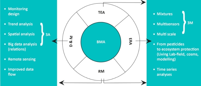
- 3A’s - Analysis: trend & time series analysis, spatial analysis, big data analysis. This includes, for example, analyses that improve our understanding of the relationship between land use and pesticides in surface waters;
- 3M’s : effects of Mixtures, Multi stressors and Multiple scales. Current environmental risk assessment often looks at single substances at a certain location. However, in reality, many substances co-occur in the surface waters in the Netherlands, and this may have strong implications for the local biodiversity and functioning of the ecosystems. Moreover, increased nutrient loadings are often found together with pesticide exceedances; such a multi-stressor environment may result in a different (and sometimes unpredictable) response than a response to only one stressor. Lastly, effects of pesticides (and other stressors) on water fauna can be measured at different scales - both in time (for example, acute response of water fauna to exposure versus the effect on their reproduced offspring) and in space (for example, in a petri dish, aquarium, meso-cosm or living lab experiment). The responses as measured on a smaller scale are not always easy to link to the responses measured at higher scales, due to an increased complexity of the system (for example from one species to a whole ecosystem). Studying the effects at different scales allows for an increased understanding of key processes and mechanisms involved;
- Improving monitoring design in time and space to develop improved governmental environmental risk procedures (e.g. accounting for relevant biological periods/seasons);
- Improve dataflow: using api, cloud and web services to efficiently move from monitoring by water boards to maps of standard exceedances in the Pesticide Atlas.