
Research project
The Maaskant Project
The research programme of the Prehistoric Farming Group (European Prehistory) has several research projects. The largest and longest in terms of continuity is the Maaskant project directed by prof. dr. Harry Fokkens.
- Contact
- Harry Fokkens
The Maaskant Archaeological Project
The project was initiated in 1979 by G.J. Verwers as the Maaskant project and in 1983 adopted by the present leader of the project, prof. dr. H. Fokkens. The aims and goals have changed considerably in the course of the project and are now centered around settlement and landscape in the entire area between the Peel marshes and the river Meuse, an area that was known as Maasland since the thirteenth century. Within this research area we are interested in long term developments of farming economy, social structures, ideology and burial ritual. Ultimatly we want to find out how these aspects of life are combined in the cosmology of the communties south of the river Meuse. These aspects are studied diachronically from the Late Neolithic through the Roman Period, both within the study area as in relation to the wider region of the southern Netherlands and Northern Belgium.
On this supra-regional level the interaction with the Amsterdam colleagues who also work in the same region with comparable interests is important. Between 1996 and 2001 this interaction took shape of the research project - Settlement and landscape in the Maas-Demer-Scheldt region - subsidised by the Dutch Organisation for Scientific Research (NWO), and the Universities of Leiden and Amsterdam. In 2010 an NWO Odyssee grant was obtained to prepare the final publication of the sites excavated between 1986 and 1995.
In 2011 the project came to an end. No new fieldwork is being carried out by the Faculty because commercial Archaeology has taken over most field work. We are involved in synthetic research every now and then because the expertise that has been built up over the years is almost irreplaceable. Much of this expertise has been consolidated (valorised) by the appointment of project member Richard Jansen as part time municipal archaeologist of the municipality of Oss.
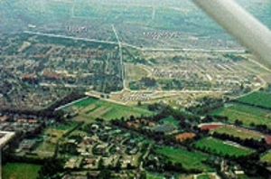
The Maaskant Region
The Maaskant is the zone of riverine clays and silts south of the river Meuse between the towns of ‘s-Hertogenbosch and Ravenstein. It means ‘side of the Meuse’ as opposed to ‘side of the heath’ (in Dutch Heikant), which indicates the sandy area to the south of the Maaskant which in Medieval times was covered with heather fields. For research purposes we consider the whole region between the river Meuse in the north and the extensive Peel marshes the river Aa in the south and the west as our study area.
Sites excavated since 1974
The Maaskant area is presently one of the most intensively researched areas in Northwestern Europe and a sound basis for models about the way in wich farming communities used and structured the landscape. Since 1974 many new built estates have been subjected to archaeological research first.
- Oss-IJsselstraat (1974, 1975)
- Oss-Ussen (1976- 1984)
- Oss-Suikerkamp (1986)
- Oss-Mikkeldonk (1987-1988)
- Oss-Kraaijenest (1988-1989)
- Oss-Schalkskamp (1990-1992)
- Oss-Mettgeupelstraat (1993-1994)
- Oss-Almstein (1995)
- Oss-Vorstengrafdonk (1997-2003)
- Oss-Horzak (1997-2009)
- Oss-Zevenbergen (2004-2009)
- Uden-Slabroekse Heide(2010)