
Research project
Emergency recording of Chontales style sculpture at the El Gavilán site, Central Nicaragua
The scientific interest in stone sculpture has been present in the archaeological investigation of Nicaragua from the mid 19th century onward.
- Duration
- 2009 - 2010
- Contact
- Alexander Geurds
- Funding
-
 Veni NWO
-
 Project Grant from Dumbarton Oaks
- Partners
The Nicaraguan Institute for Territorial Studies (‘INETER’)
Clemente Guido: co-Director of the Nicaraguan Institute of Culture (‘INC’)
INC Department of Archaeology, in particular its Director Blanca Aráuz
The community of El Ayote and Mayor Ramon Alberto Gutierrez Crovetto
Don Alberto Gutierrez, owner of the Farmstead St. Eduviges
Introduction
The scientific interest in stone sculpture has been present in the archaeological investigation of Nicaragua from the mid 19th century onward starting with the central Nicaraguan travels of the Austrian Knight Emmanuel von Friedrichsthal, to be followed by for example the well-known US diplomat and archaeologist Ephraim Squier. The enduring character of stone sculpture and its evocative associations to questions of monumentality and memory provided for this steady stream of attention, particularly in neighboring Mesoamerican hot-beds of monumental sculpture such as the Preclassic period, the Classic Lowland Maya or among the Late Postclassic Mexica. Stone sculpture formed one of the most important object categories for exploiting rock outcrops in the Central America during Pre-Columbian times. This quarrying supplied raw material for carving monumental statues and presumably applying them as structural elements in ritual spaces.
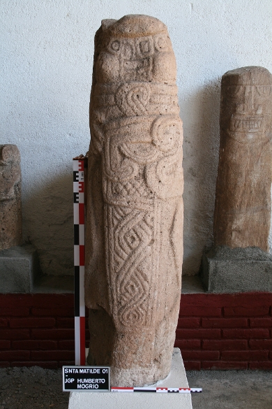
These monumental sculptures are recognized to exist in Nicaragua as a small number of distinct style groups. One of these styles, the Chontales Style, consists of sculptures distinguished by their remarkable height combined by a restricted circumference. Some exceed five meters in length and usually but most are typically no wider than 50 centimeters in diameter. Sculptures are typically carved in low relief depicting singular anthropomorphs. Both males and females are featured, some with a variety of iconographic elements (Figure 1).
The corpus known today consists solely of statues in public and private museums collections in Nicaragua, a few in the U.S. and a single example in Europe. Contrary to other stone sculptures traditions in the Americas, almost nothing is known about the functionality and meaning of these central Nicaraguan sculptures. Apart from museum archival references roughly indicating region of provenience for some of these objects, the majority lack any form of information related to their archaeological site of origin. For a long time, this has precluded studies into their architectural context and social meaning. The archaeological site of El Gavilán (N-RAAS-AY-1, previously denominated as Nawawasito), documented in 2009 in central Nicaragua (El Ayote), now provided the opportunity to begin researching the spatial context of these statues.
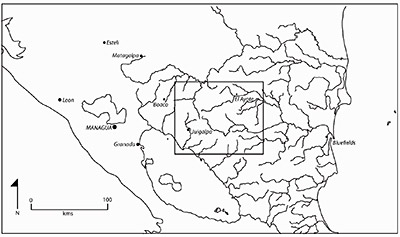
El Gavilán is located strategically at the confluence of the Siquia River and its tributary the Nawawas in the municipality of El Ayote. It is approximately 8 hectares in size and is situated in the transitional zone between the central watershed region to the west and the Caribbean lowlands to the east (Figure 2).
Upon initial documentation and subsequent sketch mapping, the site yielded a significant number of stone sculptures related to the Chontales style of anthropomorphic sculptures found in the region bordering Lake Nicaragua to the north. At least 13 sculptures were found to be nearly completely intact and another 31 were counted based on large fragments. All monoliths displayed severe weathering in the form of discoloration, leaching, and animal induced damages. Roughly two-thirds of the entire corpus display modified exterior surfaces in the form of low relief and incision carving. The uncarved monoliths are all 4 to 6 feet tall fragments of columnar basalt, an igneous rock which cools to form conspicuous polygonal joints, resulting in tall and narrow columns. As such, the monoliths, even though uncarved, present the beholder with a distinct anthropogenic quality.
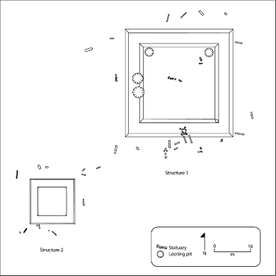
The site is centered around two quadrangular stepped mounds, which have most of the sculptures in their immediate vicinity (Figure 3). The site is located entirely on the private property of a cattle rancher. This landowner, a person with considerable social capital in the El Ayote area, has effectively ensured the protection of this site from looting. Its extraordinary value for both archaeology and heritage purposes warrants the current inventory and archaeology study. For related reasons, this fieldwork aimed to stimulate the preservation of El Gavilán for future investigation and public interest. Due to their ubiquitous appearance, prehistoric stone sculptures worldwide have a history of being removed from their original location. The recent history for sculptures in Nicaragua is no different. As such, contextual data is entirely lacking for this considerable corpus of anthropomorphic statues.
Project goals, methods, and results
The following specific research goals were formulated for the January 2011 fieldwork:
-
Complete a topographic survey of the El Gavilán site, in order to map the location of the complete sculptures and associated architectural features.
-
Create a photographic registry for the El Gavilán sculptures, documenting their state of deterioration.
-
Commence an excavation program of 50 x 50 cm shovel pits, in order to determine the extent of the site, verify the presence of habitation traces and, if possible, collect carbon samples for dating purposes.
-
Develop protective measures to limit risk of looting and preserve the integrity of the site.
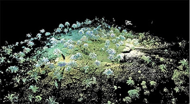
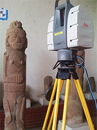
The Dumbarton Oaks Project Grant enabled the complete recording of the El Gavilán archaeological site by applying non-destructive techniques. The topographic mapping was completed utilizing three instruments that precisely measure distances; the Leica HDS 3000 3D Scanner (Figure 4), the Leica TCRA 1103 Total Station and the Leica Viva GS 10 GPS system. The 3D Scanner was the instrument of choice because we were able to capture millions of points in order to generate a detailed Digital Elevation Model (DEM) of the site contours (Figure 5). The Total Station was used to refine the limits of the mounds and to set the X, Y and Z control that was needed to tie in the survey. The GPS System was used to gather X, Y and Z positions to tie in the survey to the world coordinates. This DEM now provides the baseline for future archaeological and heritage related activities at the site and will enable the monitoring of sculpture degradation caused by environmental factors, mainly meteorological conditions and anthropogenic activities.
Test excavations
In order to begin to address whether the archaeological site was an area of continuous human habitation or one of peripheral activity with periods of abandonment, a total of 26 shovel tests (50 x 50 cm or 1 x 1 m) were dug in the southeast and northeast periphery of the site (Figure 6).
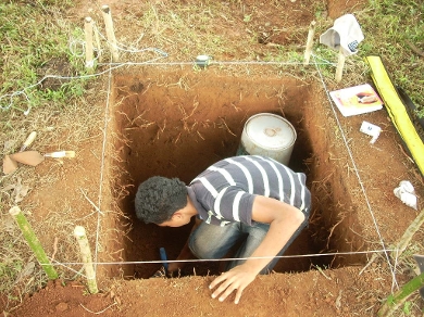
The results of these 40 to 60 centimeter deep wide shovel tests did indeed reveal ceramics and lithics (mostly debitage fragments), however in remarkably low quantities. In addition, small fragments of dried clay were recorded clearly indicating the presence of wattle-and-daub walls. Whereas the small quantities of pottery would otherwise point to temporary campsites, the latter wall fragments significantly complicate such an interpretation, instead indicating at least semi-permanent settlement at El Gavilán. It should be noted however, that due to time constraints, the shovel testing did not include the northwest and southwest sectors of the site. Whether El Gavilán was thus a multicomponent site or not cannot yet be ascertained at this time. Three charcoal samples were submitted for standard AMS radiocarbon dating, and are currently being processed (BETA Analytic 294640, 294641, 294642).
Geophysical Prospecting

In terms of scale, engineering complexity and architectural refinement, the El Gavilán site is not categorically different from other traces of monumentality known in Nicaragua today. What does set it apart is the diverse range of stone materials employed. In order to begin address the practices of megalith technology at El Gavilán, a classification of the lithic materials used on site was established, including the types of rock used for the megaliths (Figure 7), as well as material used for construction of ceremonial mounds.
Four rock types were identified, consistent with the observed diversity of rock material at the Juigalpa museum. Once having identified this lithology, a study of the geophysical characteristics of the surrounding area was conducted, to identify possible spots of origin for stone materials processed at the site. Based on coinciding petrology, general morphology and overall proximity to El Gavilán, the raw materials for the construction of the monumental mounds and the creating of the megaliths appear to come from a hinterland area of some 1.5 to 2.0 kilometer distance. However, this preliminary finding will still require testing by petrographic techniques. Small samples taken from the site will be compared with samples from outcrops to see if these rock types are indeed identical.
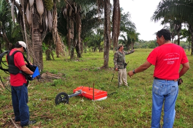
Ground-penetrating Radar Study
In collaboration with the Geophysical department at INETER, the central area of the site, including Structures 1 and 2 were included in a GPR study (Figure 8). A grid of closely spaced north-south and east-west transects was walked in order to cover an 80 by 80 square meter area including the entire monumental sector of the site. In addition, a smaller grid was completed to include Structure 3, one of the larger earthen mounds at the site. Most of the data processing, including reflection profiles and horizontal imagery is still pending completion and should reveal whether Structures 1 through 3 contain any relevant subsurface features.
Site conditioning
A parallel project initiated in 2011 is to develop adequate measures of protection for the site and in particular the megaliths. This will include cleaning, repositioning and roofing for many of the intact sculptures, while maintaining a low-budget (and therefore more feasible) financing structure. The landowner, the El Ayote municipal authorities as well as Patrimonio Cultural and the Museo Nacional have expressed an interest in supporting these plans. The former two parties have already conditioned the 8 kilometer gravel access road between El Ayote and the site itself. Whilst El Gavilán is not an immediate tourist magnet due to its remote location, the sheer unique character of the site alone merits its conditioning and protection. Additional financing is potentially also available from the National Museum of Ethnology in The Netherlands.
Conclusion
The fieldwork in El Ayote continuously involved the local community, both by means of the interest expressed by the municipal authorities as well as through questions and comments posed by surrounding inhabitants of the El Gavilán site. This dialogue was crucial for the success of the fieldwork since it not only allowed it to take place, but also resulted in several instances in which information was shared concerning other locations that potentially may prove to have in situ stone sculptures. Most of these locations however are located at several hours (sometimes days) of travel further to the east of El Gavilán, making visual inspection a decidedly challenging affair. Also, the involvement of persons at the local level is of importance in ensuring the (limited) protection of the statues, at least safeguarding them from the interests of looters.
The initial goals for this fieldwork, detailed recording of the sculptures and their context, as well as initiating our understanding of El Gavilán’s extent and occupational history, were largely achieved. Our activities at the site generated the interest of the community and this was answered by providing occasional talks during public meetings, interviews on local radio and discussing the site’s importance with anyone keen of learning about it. As such, the final goal of providing measures of protection for the site were met, albeit that protecting and developing this site is certainly a long-term endeavour, one which we foresee will continue to require attention during upcoming field seasons.
Acknowledgements
This field research was made possible by a generous Project Grant from Dumbarton Oaks. The research was also supported through National Geographic Society CRE Grant 8805-10. The Central Nicaraguan Archaeological Project is conducted as part of a ‘Veni’ Fellowship granted by the Netherlands Organization for Scientific Research (‘NWO’). I would like to thank the former co-Director of the Nicaraguan Institute of Culture (‘INC’), Clemente Guido, for his interest and support, as well as the INC Department of Archaeology, in particular its Director Blanca Aráuz. The community of El Ayote and Mayor Ramon Alberto Gutierrez Crovetto are thanked for the profound interest in scientific research of the local archaeological heritage. A special thanks also to Don Alberto Gutierrez, owner of the Farmstead St. Eduviges, and astute protector of the El Gavilán archaeological site. The Nicaraguan Institute for Territorial Studies (‘INETER’) participated in this geophysical research included in this fieldwork and Jane Chadwick (Free University Amsterdam) executed the macroscopic lithography on the stone sculptures. Calvada Surveying was instrumental in completing the 3D laser scanning; Jorge Vazquez is warmly thanked for making sure this collaboration was realized. Jorge Zambrana and Carlos Villanueva ensured the fieldwork was a success. Laura Van Broekhoven’s role in this fieldwork initially was and remains fundamental.