
Research project
Spatial patterns in landscape archaeology
This PhD project develops and applies a GIS procedure to use legacy survey data in settlement pattern analysis. As part of the research by the LERC project (NWO, Leiden University, KNIR), legacy data produced by surveys in central and southern Italy are examined in a comparative framework to investigate settlement patterns in the early Roman colonial period (3rd century BC).
- Duration
- 2013 - 2018
- Funding
-
 NWO Free Competion Grant
- Partners
A GIS procedure to study settlement organization in early Roman colonial territories
Research question
Which is the most probable settlement model for the organization of rural landscapes in the early Roman colonial period?
Project description
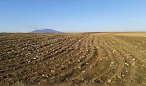
During the last decades in Italy, many archaeological fieldwalking surveys were executed producing large amounts of data. In several regions, legacy survey data registered and mapped by these previous surveys represent the only remaining source of information to study archaeological sites and reconstruct the past. This is because unregulated recent transformations related to intensive agriculture, erosion, construction work, and urbanization are currently incisively changing the soil and destroying the archaeological sites on and under its surface. Legacy survey data about these sites, collected in the field before recent massive destructions, form an extremely important record for studying the past.
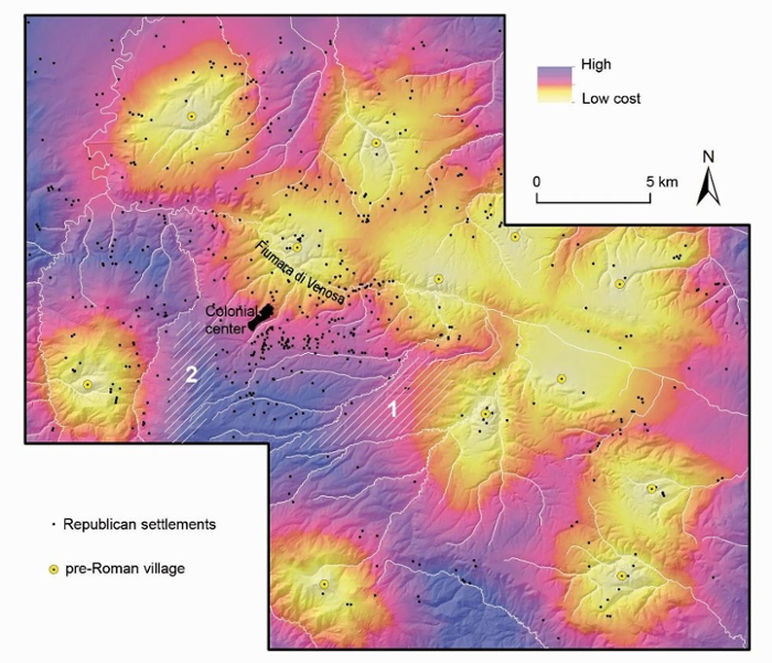
Methodological procedures are necessary to cope with the limits of these data, and more importantly with the distortions on data patterns caused by biasing factors. This research project develops and applies a GIS procedure to use legacy survey data in settlement pattern analysis. The GIS procedure unfolds in two parts. One part assesses the effect of biases on site-based survey datasets (i.e. the application of bias-testing approaches). The other part aims to extract historical meaning from data patterning. To show how the proposed GIS research procedure works in practice, in this project a case-study is employed. The project explores the impact of Roman conquest and colonization in central and southern Italy through the analysis of patterns in site location preferences exhibited by survey data. More specifically, legacy data collected by three survey projects in the territories around the ancient towns of Venusia (291 BC), Cosa (273 BC) and Aesernia (263 BC) are used to investigate settlement patterns in the early Roman colonial period (3rd century BC).

Two settlement models
By applying the proposed GIS procedure, two distinct settlement models about Roman colonization which presume radically different site densities and patterns, were tested. The aim was to establish which one is more probable based on survey data. The first model presumes the existence of a dense and evenly dispersed distribution of farms in landscapes that were settled by Roman colonists. The second, in contrast, proposes a nucleated settlement model, hypothesizing that villages, rather than dispersed farms, dominated in early colonial landscapes.
New insights
Not only did the presented GIS procedure permit to establish which scenario is more likely to have occurred in the past, it also produced entirely new insights into the settlement organization of early Roman colonial landscapes. This study provides evidence that the survey data strongly match the nucleated settlement model in terms of settlement density and site patterns. It also permitted to establish that the site clustering preferentially targeted specific landscape zones thus suggesting that a precise rationale determined colonial-period settlement strategy.
The main results of this project are published in:
- Casarotto, A. (2018). Spatial patterns in landscape archaeology: A GIS procedure to study settlement organization in early Roman colonial territories. ASLU 43. Leiden University Press.
- Casarotto, A., Stek, T.D., Pelgrom, J., van Otterloo, R.H. & Sevink, J. 2018. Assessing visibility and geomorphological biases in regional field surveys: the case of Roman Aesernia. Geoarchaeology, an International Journal 33 (2), 177 – 192.
- Casarotto, A. 2017. A method for modeling dispersed settlements: visualizing an early Roman colonial landscape as expected by conventional theory. Archeologia e Calcolatori 28 (1), 147-163.
- Casarotto, A., Pelgrom, J. & Stek, T.D. 2017. A systematic GIS-based analysis of settlement developments in the landscape of Venusia in the Hellenistic-Roman period. Archaeological and Anthropological Sciences.
- Casarotto, A., Pelgrom, J. & Stek, T.D. 2016. Testing settlement models in the early Roman colonial landscapes of Venusia (291 BC), Cosa (273 BC) and Aesernia (263 BC). Journal of Field Archaeology 41(5), 568-586.