
Research project
Hidden landscapes of Roman colonization
Assessing the effects of landscape and land-use changes on the visibility of archaeological landscapes in Central-Southern Italy.
- Duration
- 2015 - 2019
- Funding
-
 NWO
NWO
-
 The Royal Netherlands Institute in Rome (KNIR)
- Partners
Leiden University – Faculty of Archaeology
The Royal Netherlands Institute in Rome (KNIR)
Soprintendenza per i Beni Archeologici del Molise
Soprintendenza per i Beni Archeologici della Basilicata
Research question
- Were the marginal areas such as hilltops, nowadays hardly accessible to traditional field survey methods, in fact inhabited during proto-historic and Roman times and can we quantify the bias induced by the underrepresentation of these zones in the survey sampling?
- To what extent do the post-depositional erosion/sedimentation processes affect the archaeological distribution map? And can this process be quantified?
- Does the geological record present evidence of man-induced environmental changes linked with changing land management strategies, that may consequently have affected the visibility of archaeological remains?
Project description
In Mediterranean landscape archaeology in general and in the LERC project in particular, interpretations rely mainly on field survey data, i.e. archaeological material visible at the surface gathered by means of pedestrian reconnaissance. These data are significantly affected by biases such as field methodology, research intensity, and accessibility and visibility factors. This PhD project aims to add to the important debate on Roman colonization in Italy by assessing the impact of environmental and/or manmade changes in landscape and land-use on the visibility of the archaeological record. The method that will be developed and tested in this project, however, is also relevant for other time periods and regions, and as such has also a wider applicability for other areas of archaeological research.
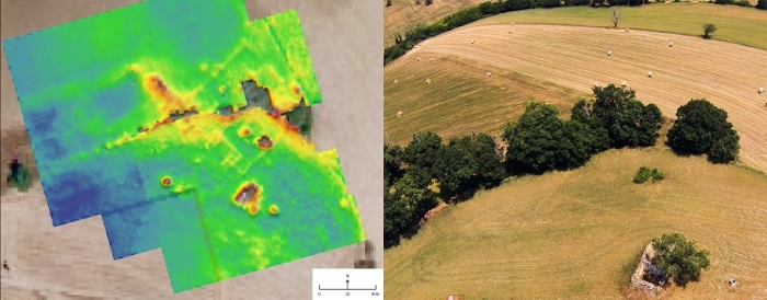
During field surveys, interpretations about the nature of the sites -- whether it is a small farmstead or a large villa for instance -- are based on the nature, the extent and the density of the archaeological material laying at the surface. Nevertheless, in nearly every cases, no excavation is able a posteriori to infirm or confirm these interpretations. In this part of the research, we aim to relate the surface signal with other prospection methods to refine the interpretations. These methods are the geophysics (mostly georesistivity) and remote sensing by mean of both satellite and drone imagery. In addition the study of the geomorphological processes in action in these unstable hilly landscapes, where landslides are frequents, may add to the interpretation of the field survey results.
So far, the geophysical investigations of most of the surveyed sites in the study area have shown a good correlation between the material density at the surface and the underlying structures. However, it is not the case for every sites, and the causes of this poor correlation are still to be investigated. Possible factors for sites (in-)visibility may be the present and past land-use practices or geomorphological processes, chiefly rill erosion and landslides. The combination of these prospection approaches will give a better insight of the correlation between the field survey interpretations and the possibly preserved underlying structures.