
Fieldwork campaign
Dominican Republic
To what extent is the image of the Taino settlements on Hispaniola representative for the whole island, or is it only related to a few large settlements of known caciques?
- Duration
- 2004 - 2010
- Funding
- "Life and death in a Taino community. The interplay of quotidian and ritual behaviours in the pre-Columbian Dominican Republic"
-
 NWO research project “Houses for the living and the dead, organisation of settlement space and residence rules among the Taino, the indigenous people of the Caribbean encountered by Columbus.”
- Partners
- Museo del Hombre Dominicano
- Institute of Archaeology-University College London, Dr. José R. Oliver.
- CNRS (Centre National de Recherche Scientifique), Dr. Stéphen Rostain

Short Abstract
In July 2004, a cooperation started between the Faculty of Archaeology and the Museo del Hombre Dominicano and the (University College London, England, Dr. José Oliver), to explore the possibilities to jointly undertake archaeological investigations in the Dominican Republic. Excavations would take place in the context of a fieldschool bringing together students from the United Kingdom, the Netherlands and the Dominican Republic.
2004 campaign
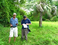
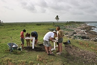
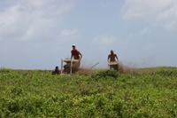
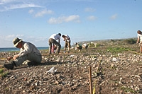
The main purpose of this first reconnaissance was for the investigators to familiarize themselves with the archaeology of the Dominican Republic. Known sites around the island were visited. The 2004 campaign took place from the 13th till the 27th of July and focused on the north (16th-17th July) and east (19th- 21st of July) coasts of the island. A fieldtrip was also made in western direction to the site of Barrera Mordán. The project was highly successful. Information was collected on all of the sites and coordinates were recorded. Pottery samples were taken from nearly all sites for technological analysis to be conducted in cooperation with the Ceramic Laboratory at Leiden University.
 Besides the site prospections, several major artifact collections were also visited and photographed. In this respect visits were made to the Museo del Hombre Dominicano, the Sala de Arte Pre-Hispánico of the Fundación García Arévalo, Inc., and the collection of the as well as the small collection of Amerindian artifacts at the Museo Nacional de Historia y Geografía.
2005
In July 2005 this co-operation came to fruition, and based on the knowledge gained from the 2004 survey, archaeological investigation began at the site of El Cabo on the east coast of the Dominican Republic in the Higüey region, province of Altagracia. This project is an ongoing cooperative venture between the Museo del Hombre Dominicano, Leiden University Faculty of Archaeology, and the Institute of Archaeology-University College London. Until 2010 part of the project entitled “ Houses for the Living and the Dead” will be financed by the Netherlands Foundation for Scientific Research (NWO).
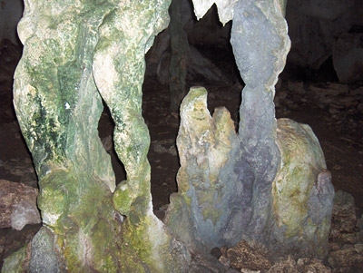
 El Cabo is set in a dramatic cultural landscape, directly on the coast overlooking the Mona Passage towards Puerto Rico and against a backdrop of limestone Pleistocene cliffs which shelter many caves, some of which show evidence of use in pre-Columbian times. The modern village of El Cabo is just next-door and provided our daytime base. Local inhabitants joined the project and helped excavate and wash finds. The 2005 fieldwork focused on defining the limits, layout and occupation phases of the site.
 Preliminary results suggest the stratigraphy at El Cabo bears witness to a dense occupation in two main phases between approx. AD 600 and 1400. The varied artifact assemblage, including pottery and stone, bone, shell and coral tools and ornaments demonstrate the inhabitants were engaged in a broad range of activities related to craft production and exchange of products. Most significantly, dense clusters of features cut both into the sandy soil and the bedrock present opportunities to interpret structures and spatial organization of a Late Ceramic village.
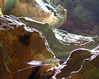
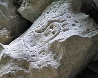
 As well as excavation of El Cabo, some of the group walked more widely in the surrounding area to the explore caves, sinkholes and marshy areas which make up the diverse environment. Small-scale investigations were also carried out in another site, Sitio de Pepe, to the north. This enabled familiarization and regional comparison. Trips were made further afield to caves in the locality such as the Cueva de Berna in the Parque del Este, the walls of which are adorned with Taino petroglyhs.
El Cabo is set in a dramatic cultural landscape, directly on the coast overlooking the Mona Passage towards Puerto Rico and against a backdrop of limestone Pleistocene cliffs which shelter many caves, some of which show evidence of use in pre-Columbian times. The modern village of El Cabo is just next-door and provided our daytime base. Local inhabitants joined the project and helped excavate and wash finds.
The 2005 fieldwork focused on defining the limits, layout and occupation phases of the site.
 Preliminary results suggest the stratigraphy at El Cabo bears witness to a dense occupation in two main phases between approx. AD 600 and 1400. The varied artifact assemblage, including pottery and stone, bone, shell and coral tools and ornaments demonstrate the inhabitants were engaged in a broad range of activities related to craft production and exchange of products.
Most significantly, dense clusters of features cut both into the sandy soil and the bedrock present opportunities to interpret structures and spatial organization of a Late Ceramic village.
As well as excavation of El Cabo, some of the group walked more widely in the surrounding area to the explore caves, sinkholes and marshy areas which make up the diverse environment. Small-scale investigations were also carried out in another site, Sitio de Pepe, to the north. This enabled familiarization and regional comparison. Trips were made further afield to caves in the locality such as the Cueva de Berna in the Parque del Este, the walls of which are adorned with Taino petroglyhs.
A geophysical pilot-study 2006
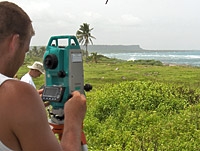
After the first summer of fieldwork in 2005, a team from Leiden led by Alice Samson, together with Dr Branko Mušič from Ljubljana University (Slovenia), carried out a geophysical pilot-study in El Cabo, in April-May 2006, to test the potential of various techniques on the site. This fieldwork was funded by a National Geographic Research and Exploration grant (PI Alice Samson 2006). The aim was to see whether geophysical methods were suited to the terrain and whether we could identify and map posthole features.
0.4ha was covered over 10 days using a combination of magnetometry (Geometrics G-858) and ground-penetrating radar (400MHz). Magnetic prospection and GPR were executed in parallel profiles of 25cm.
GPR (i.e. sending energy pulses into the ground to measure the depth of anomalies) and magnetometry (measuring differences in the magnetic field of subsurface materials) are non-destructive ways of carrying out large-area investigation.
Three different types of anomaly were identified as being of archaeological origin. Area 1, showing strong thermomagnetisation, may represent an area of prolonged past burning, burnt clay or dense accumulations of powdered ceramics. Areas 2 and 3 produced small-scale anomalies with a circular appearance in plan view, suggestive of the posthole features excavated in 2005. The strong linear anomalies running east-west are caused by iron nails in the fence (see photograph). The difference in magnitude of the anomalies on the north and south side of the site is due to different geological properties of the background.
As well as providing geological/geomorphological information to aid interpretation of the magnetograms, GPR time slices (with steps of 1-2 ns) create excellent sets of plan views at depths of every few centimeters. Predictive models are currently being explored which combine georadar data and archaeological data (from excavated trenches). A previously excavated area dense in posthole features was back-filled with excavated soil and re-used as a test area for both geophysical methods. Even though the former conditions could not be exactly replicated, this empirical approach can provide us with some additional information about the magnitude and shape of anomalies generated by known features and lead to more reliable archaeological interpretation.
Identification of configurations of larger postholes will enable reconstruction of the Amerindian structures on the site. A combined future approach which uses geophysical information as a guide for archaeological excavation strategy may be an effective way of investigating site features.
2006
 The 2006 field season on the east coast of the Dominican Republic was successful in refining ideas from the 2005 fieldwork on site activities and diachronic structuring of domestic space in the Ceramic Age in the archaeological village of El Cabo.
The focus of investigation this summer was the enlargement of the trench excavated on the bedrock area of the site in 2005 (referred to in documentation as 84-29/39/49), and the strategic excavation of 2m x 2m test-units to refine ideas on the layout of El Cabo – where the midden and swept areas occur with respect to house areas - how occupation patterns changed over time, and to establish a detailed typo-chronology of material culture.
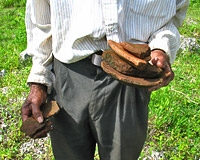
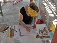
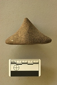
This involved excavation of culture layers in 1 metre squares, and fine-sieving material to collect the ceramic, stone, shell, coral, lithic and bone remains. Artefacts recovered, such as the stone ‘three-pointer’ (thought to embody ancestor spirits and ensure protection) and various shell, lithic and bone parapharnalia, food remains and raw materials from the culture layer will be looked at in combination with evidence of the features to build up a picture of site activities.
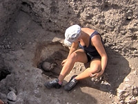
 Dense clustering of (mainly) posthole features were again encountered, dug into the bedrock. Other features such as pits, and a child burial were also revealed inside the occupation area. Remains of burnt posts were found in some of the larger postholes of one of the structures. Samples were taken for wood analysis and for dating purposes. From the field drawings of this trench, and interpretations made in the field, we were very excited to see numerous possible round and oval structures. Further investigation and continuation of geophysical work will refine these reconstructions and reveal the extent and configurations of the occupied areas. Numerous posthole features on the edge of the cliffs also require further investigation. What seafront structures might they represent? The group also ‘tasted’ some ethnoarchaeological work when Maria Villa, one of the local women, made flour and then bread for us from a tuber commonly exploited today and in Ceramic times – zamia or guáyiga. It was tasty, but rather dry!
2007
 Excavation in El Cabo was carried out in July and August 2007. As in 2006, this was concentrated in two activities: firstly, extending the large excavated area (84-29/39/49), and secondly, excavating a number of 2x2m units. Teams excavated to the edge of the clifftop in the large unit and further to the north. This was done to investigate the relationship between the habitation structures and the features visible on the cliff edge.
Seven 2x2m units were dug in transitional areas of the site and areas previously unexplored. Ceramic, shell, coral and bone material from both the early and late phases were recovered to refine spatial and stratigraphic evidence for the occupation phases in the settlement.
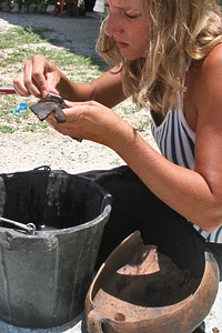
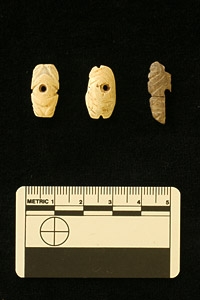
 In addition, a surface prospection was carried out over the southern half of the site. In previous seasons various members of the field direction had noted surface artefact clustering, and referred to this in conversation (“the griddle clusters on the mound”, “the coastal midden spread” etc.), yet no systematic record had been made of this other than personal notes and impressions. This area was largely covered by magnetometry (and many parts also by georadar) in May 2007 and data from both would be complementary. Survey transects were set out in 20x20 units, with 50% coverage achieved by collecting material from 2x2m units in checkerboard fashion. Throughout the course of the campaign, 3 human burials were excavated. These were all crouched (wrapped) inhumations in pits. A large number of shell and stone artefacts were recovered, including approximately 30 ground stone beads, incised shell adornments, many bearing the frog-leg motif and a large decorated threepointer made of local sandstone. One of the major discoveries of the season was the recovery of early Spanish contact material in the artefact layer in the main unit. This material consisted of a number of glass beads and green and white glazed ceramics, in the same layer as late Chicoid material. This discovery changes our understanding of the abandonment of El Cabo and the fate of its inhabitants.
Dissertation on El Cabo
For publications from this project, please consult the webpages of the project team and Dr Alice Samson's dissertation, " Renewing the House".
Relations with other projects
The field-campaigns in the Dominican Republic are under the umbrella of the pan-European project “ Life and death in a Taino community. The interplay of quotidian and ritual behaviours in the pre-Columbian Dominican Republic”
The 2005 field-campaign is related to the NWO research project “Houses for the living and the dead, organisation of settlement space and residence rules among the Taino, the indigenous people of the Caribbean encountered by Columbus.”