
This is how virtual reality brings education to the next level
Early December, lecturer Joris Timmermans gave the first virtual reality lecture at the Institute of Environmental Sciences. Together with the Centre for Innovation, he developed an innovative teaching method for the master's course Methods in Biodiversity Analysis. The first results look promising. ‘I was impressed by the positive reactions of the students.’
A lifelike virtual forest
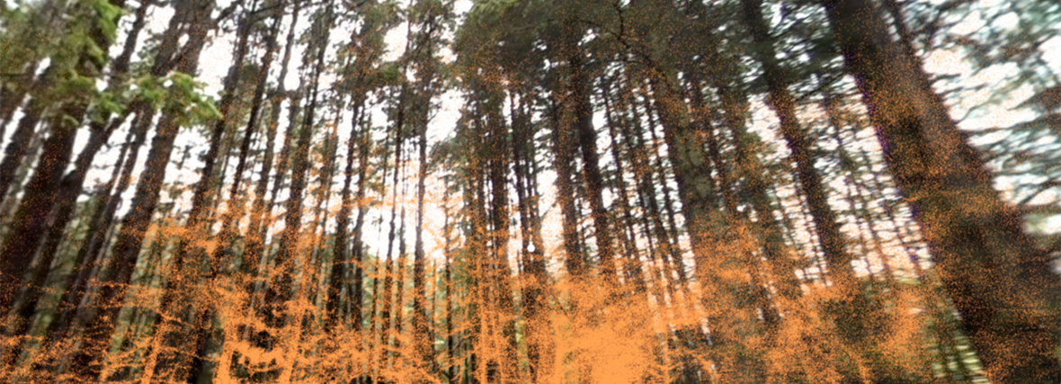
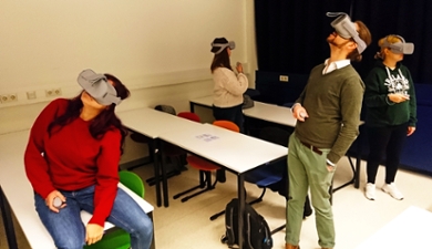
It is a strange sight: a small lecture room filled with a handful of students just standing and looking around. They can't see the brightly coloured chairs and white tables, because with their virtual reality headsets they imagine themselves in a forest filled with conifers. They can almost smell the typical fresh forest scent, that's how lifelike the experience is. ‘I just completely forgot that I was standing in a lecture room and imagined myself on the Veluwe for a moment,’ says one student when taking off the headset. Another student says he even experienced a little fear of heights when an elevator virtually took him above the treetops.
Understanding by experiencing
Goal of the virtual reality lecture: to let the students experience what remote sensing is - namely collecting data about objects or areas from a distance (see box), a frequently used method in environmental sciences. ‘I have noticed that students often have difficulty understanding the abstract concepts of remote sensing when using traditional teaching methods, which is why we started developing a new method two years ago,’ says Timmermans.
‘Tell me and I forget,
teach me and I may remember,
involve me and I will understand.’
The quote above – which is regularly attributed to the Chinese philosopher Confucius, but also to the American moralist Benjamin Franklin – describes the power of interaction. Meanwhile, interactive learning has amply earned its stripes and the idea prevails that virtual reality can add to that. ‘VR offers the possibility to visit distant areas, create scenarios and measure with expensive equipment from the comfort of the classroom,’ explains Timmermans. ‘Such an experience is therefore not only “cool”, but also ensures a more efficient way of teaching.’
‘A unique chance’
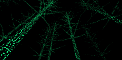
In the virtual world that Timmermans and his colleagues created, a voice-over leads the students through the forest and explains why and how certain remote sensing techniques are used. The moment the voice-over talks about scanning an environment to create a 3D model, the students are given the opportunity to get to work and scan their virtual environment themselves. They also get to see what the forest looks like with infrared radiation. Instead of green leaves, the students suddenly see the forest in white, because the infrared radiation detects the water in the leaves. ‘The fact that the students can really experience this for themselves is unique,’ says the teacher.
Students are positive
This virtual reality sounds like a fun experience, but does it add anything from a didactic point of view? To test that, Timmermans subjected the students to a knowledge quiz about remote sensing and a questionnaire about their experiences. ‘The students were very enthusiastic about the idea and even more so after they had tried the virtual reality headset,’ says Timmermans. ‘They were also positive about how the app helped them understand remote sensing.’ Timmermans also used a quiz to measure how well the VR app could contribute to knowledge transfer. This showed that by using the app, students absorbed the complex concepts faster than they would have done if they had only had the traditional way of teaching.
Timmermans emphasises that these are preliminary results: ‘This is a small group of students, so further testing is needed.’ The preliminary conclusion: with virtual reality, a new door seems to have been opened for lecturers and students.
Remote sensing
Remote sensing is the science of collecting information about objects and areas at a distance, usually using aircraft or satellites. In most cases, it concerns earth observation, but remote sensing can also be used in astronomy: for this purpose the Leiden Centre for Environmental Sciences is currently working together with the Leiden Observatory. Other applications are the mapping of environmental problems, meteorological observations and military defence.
Text: Bryce Benda