

Fieldschool 2019: Colonial Mobilities in the Andes
This summer, Dr. Noa Corcoran-Tadd and four undergraduates from Leiden’s Faculty of Archaeology have been conducting the Colonial Mobilities in the Andes 2019 archaeological survey in southern Peru. Working in conjunction with a project led by Dr. Sarah Baitzel (Washington University in St Louis), Arturo Rivera and Bárbara Carbajal, the Leiden team explored a landscape that connected productive coastal valleys with highland and altiplano centers during both the late prehispanic and postconquest periods. Following several weeks of work in the field, the Leiden students (Ewout van der Meulen, Jasper Oolders, Louise van Schaik, and Victoria Davies) put together the following post on what they had seen so far:
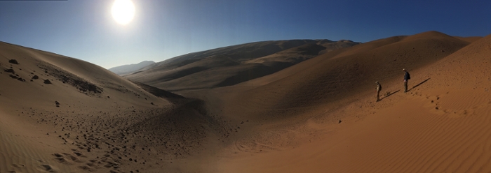
We are surveying in the Atacama Desert on the fringes of the Sama Valley in southern Peru, near the international border with Chile and Bolivia. Because of the arid nature of the desert, there is little sedimentation, which means that everything stays on the surface. Through surveying, we can find artefacts on the surface and locate possible sites. We have eleven survey blocks, located in places where there are caminos troperos. These are old roads through the desert, some of which originally formed parts of the Inca road network that later were re-used during the colonial and postcolonial periods.
We are currently looking at finds from a variety of time periods. We found some projectile points from the Archaic period (c. 14,000 to 1800BC), ceramics from the Late Intermediate Period and the Late Horizon (c. AD1000-1532), as well as fragments from colonial transport vessels (botijas). We focus on many different time periods to look at the changing uses of the landscape and the many roads and trackways that traverse the Andean landscape. As one of the main focuses of the wider NEXUS1492 project is to identify networks before and after the Spanish colonization of the Americas, our focus on inter-valley exchanges is particularly interesting.
Before going into the field, we use remote sensing to look at the landscape in and around the Sama Valley. We mainly use satellite imagery to find out where possible sites or tracks are located, and when we find areas of interest on the satellite images, we go into the field to take a closer look at these sites. In the field we use systematic pedestrian survey to see whether there are any visible archaeological remains in the landscape.
Because we are working in a desert environment, there is little ground cover to block the view, which often makes it easy to spot the artefacts and features we are looking for. The desert floor is a palimpsest where artefacts from the Archaic to the present can be found. This makes finding sites and tracks relatively easy compared to other landscapes, but can make dating of older material difficult, as there isn’t any stratigraphy or context to use for dating.
My favorite object found is a Spanish colonial coin. It was found in survey block 4 near an old road. The coin is not round and has irregular angles at the edges as the quality of the coinage was generally low. While round coins date from the 18th century onwards, this irregular coin (or cob) is from the 17th century. l like this coin because you can date it accurately as the year it was coined is inscribed on it. What also makes a coin special is that you are almost sure it was left behind accidently as it is not broken or found in a ritual setting. Even though the coin is damaged and the inscriptions faded, you can still make out what it says and you know for sure how it looked. Coins change overtime but keep their purpose and their value which makes it my favorite object found.