
Research project
Contested landscapes in the age of encounter
Amerindian settlement patterns and early colonial cartography in Northern Hispaniola
- Duration
- 2013 - 2017
- Funding
- This research has received funding from the European Research Council under the European Union's Seventh Framework Programme (FP7/2007-2013) / ERC grant agreement n° 319209.
Does the evidence from this area show the landscape contestation and transformations which took place in the Amerindian societies after 1492? And if so, what are their characteristics?
Short Abstract
This project wants to study Amerindian and colonial landscapes and its contestations, as a result of Spaniard arrival to northern Hispaniola and the Caribbean.
Project description
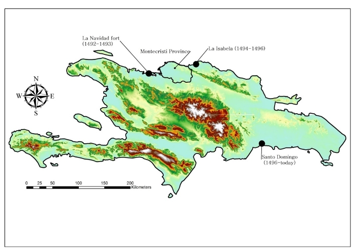
Cristobal Colón’s first contact with the people of the “new world” was in 1492 with the Taino of the Bahamas. During that first voyage, he visited also today’s northeastern Cuba and northern Haiti/Dominican Republic, which he called La Hispaniola, and where he also interacted with Taino groups. On the coast of northern Haiti the Santa María shipwrecked and with the remaining material he build a fort called La Navidad, leaving 39 men to guard it until his return (Cassá 1978; Cruz Mendéz 1999; Colón 2006). One year later, in 1493, Columbus returned with seventeen ships and 1200 men to found that the fort was destroyed and all the people killed. Because of this, he continued to sail along the coast, founding further to the east the first European “city” in the Americas, called La Isabela in honour of the Queen of Castilla and Aragon (Colón 2006) in the current northern Dominican Republic (map #1). After the establishment of La Isabela, he began the incursion south searching for gold sources, in what has been called the Ruta the Colón (ref.). Along this path Columbus build strategic forts in order to control resources and the local populations.
The Taino groups that contacted Columbus and his men were witness of the first wave of the Spanish invasion, making their contact a unique situation in the history of the Caribbean, the American continent and the world. When Columbus and his men arrived at Hispaniola, the island had a population of around 500.000 people (according to calculations of Ortega 1987). In 1519, when the Enriquillo revolted against the Spanish oppression there were around 11.000 indigenous (Ortega 1987), which means that in a quarter of a century the indigenous population in the hole island was reduced in approximately 98%. This dramatic population reduction was the result of war, slavery and diseases brought by the new comers and theirs desire for resources.

Although Spaniard invasion and conquest of Hispaniola was strong, aggressive and fast, Amerindian populations played an active role during this time. Through aggressive (guerrilla war), or peaceful means (commerce and exchange) they interacted with the Spaniards. This scenario manifests that since the beginning there was a conflict of world views and perspectives that resulted in the destruction of many societies and a colonial legacy that supress indigenous figures up to today.
The area selected to observe this issues is the coast of the Montecristi Province, which is located in north-western Dominica Republic, between the Puerto Plata Province to the east and Haiti to the west. Both, because this area is poorly known archaeologically and because it is in the vicinity to early Spanish developments, it represent an interesting area to observe the first moments of the conquest and colonization period and possibly to find evidence of these first colonial encounters and their landscape contestation.
Social relevance
The novel information generated by this research will contrast with the traditional historical studies which favor the European point of view about the contact period. The focus on the Amerindian perspective of the history will provide local populations with a new and fresh understanding of their history and the historical processes that constitutes the essence of their heritage.

Scientific relevance
This research is applying for the first time in the study region advance GIS and spatial statistical techniques, within a landscape archaeology theoretical framework to study a key moment in the history of the Americas, in the area were the colonization process began.
Why Leiden University?
The Caribbean group at the Faculty of Archaeology at Leiden University is the only in its gender in Europe and holds many of the most representative names in Caribbean Archaeology today.
Material & Methods
This research considers a multiscalar approach that goes from field surveys to data registry, processing and analysis. The idea behind it is that different scales will provide a perspective on events happening at different levels of social action.
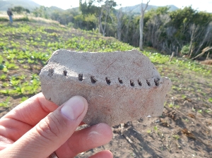
For the fieldwork a strategy based on combining systematic and opportunistic surveys, and predictive modelling was carried out between 2014 and 2015. The data registered during this time consisted in archaeological sites and its associated material culture. This data will be included within a relational database which will allow the definition of categories to be further analyse using GIS and spatial statistics.